


DreamingHawaii.com » Hawaii Islands » Oahu, the Gathering Place » Waikiki Beach » Best of Waikiki
» Waikiki Aerial Veiw
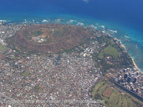
Waikiki Aerial Veiw
| Page 1 of 12 | [Jump to article page] | |
 Next | |
This aerial photo shows Diamond Head, a large volcanic crater on the southern coast of the island of Oahu. The green spot to the right of this is Kapiolani Park, and the sandy beach to the right of that, at the right of the photo, is Waikiki. (South is up in this photo.) The Waikiki area is bordered by Kapiolani Park at one end and the Ala Wai canal at the other. The Ala Wai canal is visible in the photo as a dark body of water below the skyscrapers. It wraps around Waikiki and ends up in the ocean off the right edge of this photo.
|