BIG ISLAND OVERVIEW
As the southernmost, largest, and youngest of the Hawaiian islands, the Big Island of Hawaii boasts two enormous mountains, Mauna Kea and Mauna Loa. Kailua-Kona (or just "Kona"), on the west side of the island, is the most popular place to stay. Nearby are great Kohala beaches, incredible snorkeling at places like Kealakekua Bay, ancient Hawaiian historical sites like Puuhonua O Honaunau, as well as some harsh dry terrain. On the southern coast of the island, about 2 1/2 to 3 hours away, lie the active volcanoes of Hawaii Volcanoes National Park, as well as beautiful rainforests, a black sand beach, and South Point, the southernmost point in the United States. Hilo, on the east side of the island, gets much more rain than Kona. North of Hilo are scenic drives, lush tropical waterfalls, and ancient hawaiian valleys. Majestic Mauna Loa and Mauna Kea rise from the center of the island, with the clearest night skies in the world (literally). The Hawaii Belt Road (also called the Mamalahoa Highway) makes a great circle following the coast of the island, covering about 258 miles.
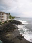
THE KONA COAST
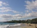
"Kona" refers to the fact that this western coast of the Big Island is in the rain shadow of the large mountains to the east. Because of the prevailing winds, this western coast receives very little rain, making your chances of a sunny day at the beach very high. The main city here is Kailua-Kona (or just Kona). If the Big Island were a clockface, Kona would be located at about 9 o'clock.
The Kona coast makes a great base of operations for an exploration of the whole island, although you will want to plan on spending one or two nights elsewhere if you do this. Beaches and related activities are abundant here, including snorkeling at Kealakekua Bay and swimming at Hapuna Beach. Plus the
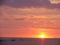
sunsets from Kona can't be beat.
THE SOUTHERN COAST AND HAWAII VOLCANOES NATIONAL PARK
A few hours of driving south from Kona brings you past South Point (the southernmost point of the 50 United States) and Punaluu Black Sand Beach to Hawaii Volcanoes National Park. Hawaii Volcanoes National Park is one of the best places in the world to observe volcanic activity close-up. Because the volcanoes are continuously releasing their energy in the form of lava flows and slow eruptions, it is relatively unlikely that a large eruption could occur here. That said, this is a place filled with dangers and you should ALWAYS consult the National Park Rangers before attempting ANY activity in or near the park. They will have the latest information on any dangerous conditions and closures. Hawaii Volcanoes National Park is probably one of the top 5 parks in the United States in terms of diversity of ecology and geology, and you will see things here that you won't find anywhere else in the world.
Explore the park at
our Hawaii Volcanoes National Park page.
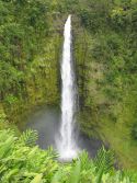
HILO AND THE EASTERN COAST
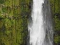
Hilo is the main city on the east-central part of the Big Island. Because the winds typically blow in from the east, this side of the island gets much more rain than the Kona coast to the west. That means that there are fewer days of good sunbathing here, but it also means that beautiful gardens, waterfalls, and fruit abound. There are two nice waterfalls practically in Hilo itself, and a few miles to the north and inland from the coast is the trail to Akaka Falls, perhaps the most famous waterfall in all of Hawaii. Hilo is also a great place to visit the Mauna Loa Macadamia Nut factory, and the Hilo farmer's market is brimming with interesting and tasty deals.
THE KOHALA REGION
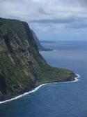
If you look at a map of the Big Island, you will notice a large peninsula sticking out on the north. This is the Kohala region of the island. The eastern side of this is dominated by great sea cliffs and includes Waipio Valley, where many traditional Hawaiian customs still carry on. The western side includes a number of Kohala coast golf courses and resorts, and is well known for its world-class amenities. In between there are highlands where ranchers still raise cattle as in days gone by. Just south of Kohala on the lower slopes of Mauna Kea is the "upcountry," also known for its ranches.
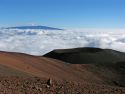
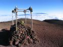
MAUNA KEA AND MAUNA LOA
The interior of the Big Island is dominated by two enormous mountains: Mauna Loa, meaning "dark mountain," and Mauna Kea, meaning "white mountain." The highland between the two mountains is traversed by a sometimes-rough road called the "Saddle Road." Mauna Kea is over 13,000 feet high and lives up to its name with frequent snowfalls and even occasional blizzards. Because of its great height, location in the center of the Pacific Ocean, relatively dry air, and distance from large cities, Mauna Kea is the top site in the world for astronomical observation. To learn more about these observatories, visit
our Mauna Kea Summit page.
Mauna Loa, to the south of Mauna Kea, is still the site of quite a bit of volcanic activity, especially along its lower slopes. It is possible to hike from Hawaii Volcanoes National Park up to the top of Mauna Loa, but this is a multi-day, extremely strenous hike and should not be attempted without proper planning and consultation with park rangers.
EXPLORE THE BIG ISLAND
As you explore the Big Island, keep in mind that the distances can be great...it takes several hours to drive from the west coast to the south coast, and about 9 hours straight to drive the 260 miles all the way around the island. There are many places where, due to small towns, curvy roads, etc., you will not be driving "freeway speeds." Enjoy the scenery!
Select from the regions below for a more detailed tour of the Big Island.